August 12th, the Furthest North open water swim in North America! Located in Sitka, Alaska.
Men's and women's age group and Relay divisions will be awarded trophies and ribbons.
Solo or relay 10k, 5k and 1k open water swims in Sitka Sound, with a water temperature range in the mid 50’s. The course will start at the Mount Edgecumbe High School ramp on Japonski Island. The course will then take the swimmers north out of Sitka Channel and westward along the Fort Rousseau Causeway State Historic Site and loop back to the Mt. Edgecumbe ramp to finish. A turnaround point in course will be available for those swimming the 5k and 1K distances.
Sanction pending with USMS.
Visit www.changeyourlatitude.org for more information.
Parents
Former Member
Up till now
sorry Kris, i beat you to it by 6 days ;) But now you've taunted me into another post.
For nearly all of Aug 1988, Redoubt Lake's surface water temperature was 57 F at it's outlet.
PDF of ADFG's 1988 Redoubt Lake water temperatures (table 16 page 37)
Redoubt is about 10 feet above mean sea level, overflowing directly into the ocean at an outlet (map link below) consisting of a short set of rapids or falls. The falls are located about 6 miles W from the USFS A-frame cabin (available for rent $35/nt) at the NE end of Redoubt. This is the cabin that Kris mentioned in a previous post. From Sitka, the falls are SW about 15 miles by boat.
2011-07-31 by John Feikema
forums.usms.org/attachment.php
The low lake elevation means that storm surge or high tides cause the flow to reverse, dumping saltwater into the lake (page 7 in PDF of Appendix C of the Tongass SEIS). The saltwater, being denser, sinks. For some reason that I don't understand, the freshwater and saltwater don't mix, setting up a halocline. Even the temperature gradients that are set up by the changing seasons are not energetic enough to turnover the lake. The upper 300 ft of the lake are fresh snow melt and rainfall, but at depths from 300 down to the bottom at 870 ft, it's salt.
It'd be easy to portage one's support kayaks around the falls were it not for the bears that feed at the falls on the salmon as they swim/leap up into Redoubt to spawn (read/listen to KCAW news report from 2011-07-22). I suspect there is some way to mitigate the danger without risk or harm to the bears (listen to KCAW news story from 2009-07-15). Or maybe one of the two bays right next door has a 400 yard trail. Sealaska, mentioned in this December 2011 write up, is the Native American owned corporation that is desiring ownership of the falls (1 page PDF summary from August 2011) under the 1971 Alaska Native Claims Settlement Act. A bit more on the long history of salmon at Redoubt Falls can be found on the lake's wikipedia page, on the this Forest Service webpage, and on Anniyah's blog.
All that was just to say this: the entrance to Redoubt via the falls may not be an option much longer. Another approach is a well used 1.5 mile CCC trail (map) that crosses muskeg and scrub timber to reach the SW end of Redoubt, starting at Goddard Hot Springs, about 18 miles SW by boat from Sitka. Yet another approach is a 6 mile hike through old growth forest on a Forest Service trail (map) at Redoubt's NE end. The trail follows Salmon Lake Creek, which spills into the head of Silver Bay at a point about 5 miles distant by kayak from Herring Cove, or 10 miles distant by kayak from Sitka.
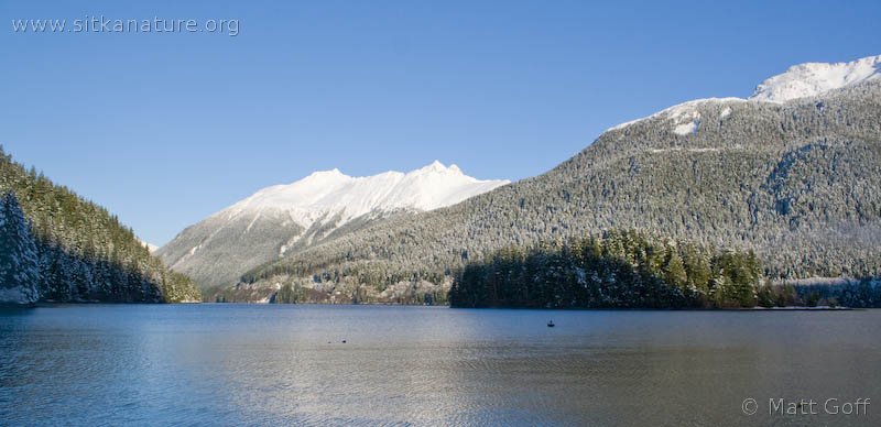
2009-11-22 Winter view looking back up Silver Bay towards Herring Cove from near the mouth of Salmon Creek, by Matt Goff
www.sitkanature.org/.../20091122-silver_bay.jpg
Or as Kris mentioned previously, there would be quick access via float plane.
Here is a link to a zoomable map of Redoubt, centered on the outlet falls. To measure distances, use the upper right hand menu to select 'Make a map', then click at any point to start your tract, continue clicking to trace out your course. Distances are displayed in the lower right. To access more options, right click on any of your markers. Or Menu -> Help for a PDF.
Even if I had been to Sitka before, I would still stand to be corrected on any of this. Mostly I hope this info helps someone plan out a world-first awesome 9 mile swim in a wild, pure-as-snow-melt, rare meromictic lake.
Bathymetry from a Forest Service brochure
forums.usms.org/attachment.php
oops, i guess this whole post is off-topic. Kris and Kevin, shall I delete it?
Up till now
sorry Kris, i beat you to it by 6 days ;) But now you've taunted me into another post.
For nearly all of Aug 1988, Redoubt Lake's surface water temperature was 57 F at it's outlet.
PDF of ADFG's 1988 Redoubt Lake water temperatures (table 16 page 37)
Redoubt is about 10 feet above mean sea level, overflowing directly into the ocean at an outlet (map link below) consisting of a short set of rapids or falls. The falls are located about 6 miles W from the USFS A-frame cabin (available for rent $35/nt) at the NE end of Redoubt. This is the cabin that Kris mentioned in a previous post. From Sitka, the falls are SW about 15 miles by boat.
2011-07-31 by John Feikema
forums.usms.org/attachment.php
The low lake elevation means that storm surge or high tides cause the flow to reverse, dumping saltwater into the lake (page 7 in PDF of Appendix C of the Tongass SEIS). The saltwater, being denser, sinks. For some reason that I don't understand, the freshwater and saltwater don't mix, setting up a halocline. Even the temperature gradients that are set up by the changing seasons are not energetic enough to turnover the lake. The upper 300 ft of the lake are fresh snow melt and rainfall, but at depths from 300 down to the bottom at 870 ft, it's salt.
It'd be easy to portage one's support kayaks around the falls were it not for the bears that feed at the falls on the salmon as they swim/leap up into Redoubt to spawn (read/listen to KCAW news report from 2011-07-22). I suspect there is some way to mitigate the danger without risk or harm to the bears (listen to KCAW news story from 2009-07-15). Or maybe one of the two bays right next door has a 400 yard trail. Sealaska, mentioned in this December 2011 write up, is the Native American owned corporation that is desiring ownership of the falls (1 page PDF summary from August 2011) under the 1971 Alaska Native Claims Settlement Act. A bit more on the long history of salmon at Redoubt Falls can be found on the lake's wikipedia page, on the this Forest Service webpage, and on Anniyah's blog.
All that was just to say this: the entrance to Redoubt via the falls may not be an option much longer. Another approach is a well used 1.5 mile CCC trail (map) that crosses muskeg and scrub timber to reach the SW end of Redoubt, starting at Goddard Hot Springs, about 18 miles SW by boat from Sitka. Yet another approach is a 6 mile hike through old growth forest on a Forest Service trail (map) at Redoubt's NE end. The trail follows Salmon Lake Creek, which spills into the head of Silver Bay at a point about 5 miles distant by kayak from Herring Cove, or 10 miles distant by kayak from Sitka.
2009-11-22 Winter view looking back up Silver Bay towards Herring Cove from near the mouth of Salmon Creek, by Matt Goff
www.sitkanature.org/.../20091122-silver_bay.jpg
Or as Kris mentioned previously, there would be quick access via float plane.
Here is a link to a zoomable map of Redoubt, centered on the outlet falls. To measure distances, use the upper right hand menu to select 'Make a map', then click at any point to start your tract, continue clicking to trace out your course. Distances are displayed in the lower right. To access more options, right click on any of your markers. Or Menu -> Help for a PDF.
Even if I had been to Sitka before, I would still stand to be corrected on any of this. Mostly I hope this info helps someone plan out a world-first awesome 9 mile swim in a wild, pure-as-snow-melt, rare meromictic lake.
Bathymetry from a Forest Service brochure
forums.usms.org/attachment.php
oops, i guess this whole post is off-topic. Kris and Kevin, shall I delete it?

